Call for Volunteers: Transit Hub Planning Program
Now in its fourth round, the Transit Hub Planning Program provides free planning assistance to New Jersey cities and towns seeking to revitalize and reconnect their communities around transit stations. Conducted jointly by the American Planning Association NJ Chapter (APA New Jersey) Community Planning Assistance Program (CPAP) and the North Jersey Transportation Planning Authority, the program is recruiting a team of volunteer community planners with the skills needed to help the Township of Berkeley Heights. The goal: develop a Transit Hub Strategic Plan specifying improvements to create a more dynamic, distinctive, vibrant, and walk-accessible area around the train station.
Community Background:
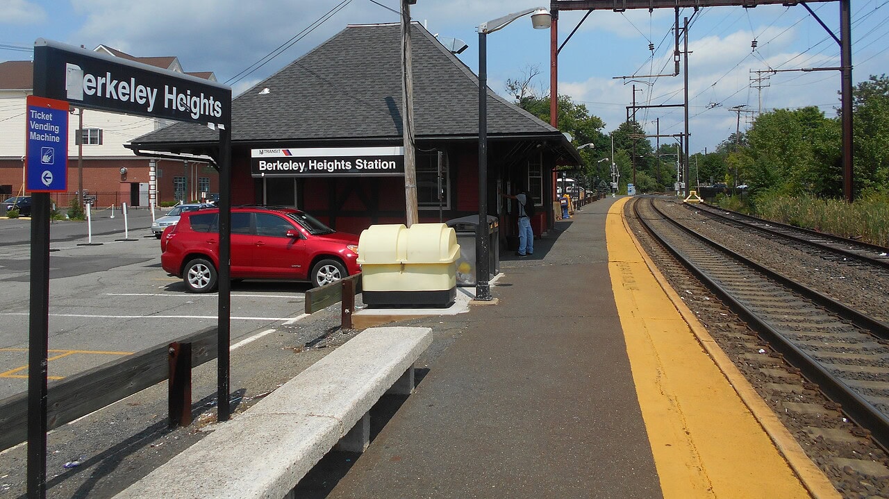
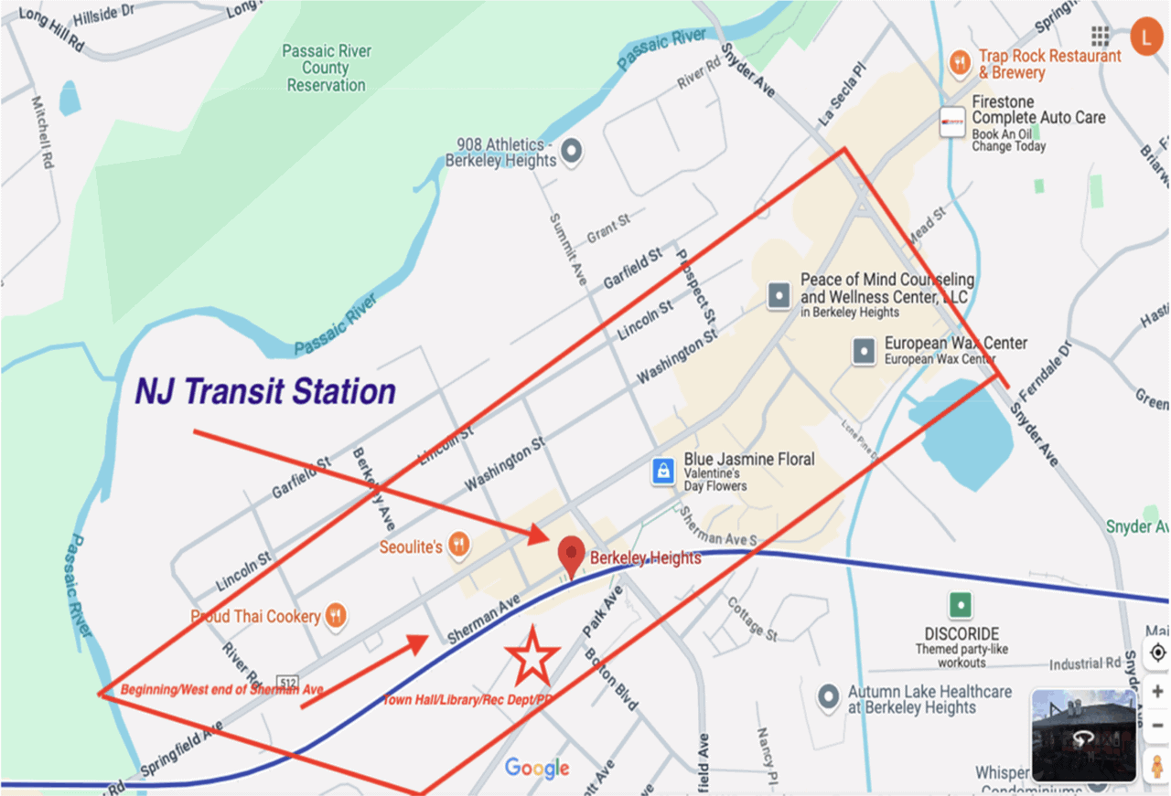
Built in 1872, the Berkeley Heights Station along today’s NJ TRANSIT Morris and Essex Gladstone Branch rail line on the western border of Union County serves approximately five hundred daily weekday riders (in 2017) who travel about fifty minutes to Hoboken Terminal or sixty minutes to NY Penn Station (via limited express service). Although there are slightly over 200 spaces in two municipally owned parking lots adjacent to the station, there is currently a 2 to 3-year waiting list for a parking permit. Because additional municipal parking is located at the municipal building across the tracks and fenced right of way from the platform, an important concern is safe commuter access via the roadway grade crossing, especially given that gates remain lowered while the train is in the station.
Berkeley Heights intends to leverage the station’s commercial district location along Sherman and Springfield Avenues by improving first—and last-mile walkability for residents and visitors and enhancing commuter parking area facilities as convertible community event spaces on weekends and evenings.
To make this possible, Berkeley Heights has adjusted zoning policy, obtained enhancement grants, and identified appropriate scale redevelopment opportunities. However, a patchwork of individually owned residential, retail, service, and commercial land uses with varying building types and sizes and off-street parking lots makes walk access challenging. Businesses, including medical and legal offices, banks, pharmacies, and restaurants, are interspersed amongst older single-family homes, vacant parcels, and the town’s three gas stations in a rural–suburban context, lessening the vibrancy of a commercial center.
To address these concerns, Berkeley Heights has encouraged the redevelopment of privately owned parcels proximate to the station through zoning permitting multi-story redevelopment. This includes commercial uses on the ground floor with heights of up to three stories. While this has generated several new multi-unit residential projects using older commercial and residential properties, especially along Sherman Avenue, complicated legacy driveway access and confusing parking areas make coordinated parking policies and direct street frontage difficult.
Although possessing a grid street system, several intersections along Springfield Avenue, a county-owned 35 MPH primary arterial roadway, municipally-owned Sherman Avenue, and the station area driveways and parking areas present pedestrian safety concerns for commuters, students, and visitors alike. The intersection of Springfield and Summit is of particular concern, with students crossing at the end of the school day to visit local businesses and area parks. Although a project to narrow vehicle lanes and widen sidewalks along Sherman Avenue is advancing, Berkeley Heights is interested in exploring additional pedestrian and bicycle safety improvements and complete streets and traffic calming strategies such as curb extensions at intersections. While the borough would also like to create more bike lanes in the station area, a bike-sharing program is not of interest at this time.
Berkeley Heights would also like to improve access between the station and several municipal and county parks within walking distance. The closest, Peppertown Park (named for the borough’s early Italian settlers known for growing and selling peppers in the area before it was developed), is popular daytimes with seniors and students after school but cannot be used to its fullest potential due to inadequate drainage. Veteran’s Memorial and Vito Mondelli Jr. Parks, just across from the municipal building, are pleasant civic spaces but lack targeted amenities. And establishing a dedicated pedestrian connection west from the station area to a new county park under construction along the banks of the Passaic River and across Springfield Avenue is desirable but remains a challenge.
Join the Team:
The city is looking to work with a team of volunteer planners to develop a transit hub strategic plan for the station area. A rigorous outreach program, which could include an online survey, focus groups, or virtual meetings, could be part of the work. The study’s results should be realistic and implementable, possibly stratified by easier-to-achieve recommendations for early successes vs. more complex improvements requiring longer lead times.
APA New Jersey and NJTPA are looking to form a multi-disciplinary team of volunteer planners to undertake this work for Berkeley Heights that will include the following skills:
- Pedestrian Safety and Complete Streets enhancement
- Community redevelopment
- Transportation and micro-mobility
- Circulation / Traffic Planning
- Zoning and Master Planning
- Parking management
- Economic development,
- Recreational facility planning, landscaping and concept design for public parks, and
- Community outreach.
Please contact Tom Schulze at or 973 634 1697 to volunteer, get more information, or ask any questions.